ROCK COUNTY PRELIMINARY MINOR LAND DIVISION – APPLICATION FORM
APPLICATION CHECKLIST
Yes
No
Comment
1.
Have you included a map clearly marked “PRELIMINARY PLAT OF SURVEY OR
CERTIFIED SURVEY MAP”, identifying the land division area and containing all of the
following information?
a.
Location of the land division area by section, township, and range:
b.
Approximate location and dimension of all EXISTING streets and property lines,
including name and ownership (if applicable), in and adjacent to the land
division area:
c.
EXISTING/PROPOSED County, Town, and City/Village (if applicable) zoning
designations of all EXISTING/PROPOSED lot(s) and outlot(s), in and adjacent to
the land division area:
d.
Approximate location and dimension of all PROPOSED lot(s), outlot(s) and
blocks(s), numbered for reference, in the land division area:
e.
Indication of all PROPOSED lot(s) and outlot(s) use if other than single‐family
residential, in the land division area:
f.
Distance from all PROPOSED lot(s) and outlot(s) point of beginning to section
corner or quarter corner, in the land division area:
g.
Approximate location, dimension (if applicable), and name (if applicable) of all
of the following, whether EXISTING or PROPOSED, in the land division area:
(1) Buildings:
(2) Streets, alleys, and public ways:
(3) Driveways:
(4) Rail lines:
(5) Private water wells or water supply systems:
(6) Private onsite wastewater treatment systems or public sanitary sewer
systems:
(7) Any other public utilities:
(8) Easements (Utility, drainageway, pedestrian way, etc.):
(9) Vegetative land cover type:
(10) Environmentally sensitive areas (Floodplain, steep slope, etc.):
(11) Productive agricultural soils, cultural resources, and woodlands:
(12) Surface water features:
(13) Drainageways:
(14) Detention or retention areas:
(15) Cemeteries:
(16) Bridges/culverts:
(17) Rock outcroppings:
h.
Approximate location, dimension, name (if applicable), and purpose of all
dedicated public parks or outdoor recreation lands, or any other public or
private reservation, including any conditions, in the land division area:
i.
Preliminary concept for connection with existing public sanitary sewer and
water supply system or an alternative means of providing water supply and
treatment and disposal of sewage, in the land division area:
j.
Preliminary concept for collecting and discharging stormwater, in the land
division area:
k.
Scale, north arrow, and date of creation:
l.
Any other information required by the Agency:
2.
Has the map been prepared at a scale not to exceed two hundred (200) feet to the
inch, with the map pages numbered in sequence if more than one (1) page is
required, and total map pages identified on each page?
3
.
Has the map been prepared by a land surveyor licensed in Wisconsin?
4.
Have you provided all required application form information and has the required
party signed this application form?
5.
Have you included a hard copy of this application form and the map, an electronic
copy of the map in a format compatible with the Agency’s Geographic Information
System (GIS), and the application fee?
THANK YOU FOR COMPLETING THE ROCK COUNTY PRELIMINARY MINOR LAND DIVISION – APPLICATION FORM.
PLEASE SEND VIA POSTAL MAIL, OR HAND‐DELIVER, THIS FORM,
A HARD COPY AND ELECTRONIC COPY OF THE PRELIMINARY MAP, AND THE APPLICATION FEE TO:
ROCK COUNTY PLANNING, ECONOMIC & COMMUNITY DEVELOPMENT AGENCY
51 N. MAIN ST.
JANESVILLE, WI 53545
REVISED 12/2011
Page 2 of 2
 1
1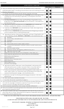 2
2


