Physical Setting - Science Worksheet Page 24
ADVERTISEMENT
 1
1 2
2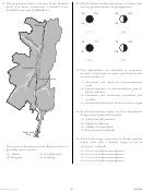 3
3 4
4 5
5 6
6 7
7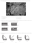 8
8 9
9 10
10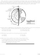 11
11 12
12 13
13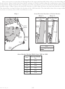 14
14 15
15 16
16 17
17 18
18 19
19 20
20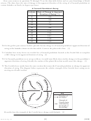 21
21 22
22 23
23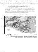 24
24 25
25 26
26 27
27 28
28Base your answers to questions 81 through 85 on the reading passage and map below and on your
knowledge of Earth science. The passage provides information regarding the eruption of a volcano in Iceland.
The map shows the thickness of ash deposits, in centimeters (cm), during the first three days of the eruption.
Point A, representing the volcano’s location, and point B, representing a location on Earth’s surface, are
connected with a reference line.
Iceland Volcano Eruption Spreads Ash Cloud over Europe
On April 14, 2010, Eyjafjallajökull volcano, located in southern Iceland, explosively
erupted, sending large volumes of volcanic ash high into the atmosphere. Much of the
ash fell quickly to Earth, as seen in the map, but large quantities remained airborne
and spread over Europe. Most of the ash was transported within the atmosphere below
10 kilometers. Air traffic across the Atlantic and throughout Europe was severely
disrupted, as airlines were forced to keep jet aircraft on the ground.
Ash
Fall (cm) April 14–16 in Iceland
63° 40′ N
20
A
10
1
B
0.5
2
3
5
63° 30′ N
Atlantic
Ocean
0.5
0.1
18° 30′ W
19° 30′ W
0
5
10 km
Source: Ash generation and distribution from the April-May 2010 eruption of Eyjafjallajökull,
Iceland, Gudmundsson et al., Scientific Reports , August 14, 2012 (adapted)
[24]
P.S./E. Sci.–Aug. ’15
ADVERTISEMENT
0 votes
Related Articles
Related forms


 - Pressure, Altitude & Density")


Related Categories
Parent category: Education