Kansaswater Pollution Control Permit Foragricultural Andrelated Wastes Permit Application Page 7
ADVERTISEMENT
 1
1 2
2 3
3 4
4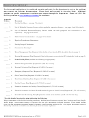 5
5 6
6 7
7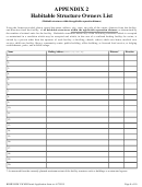 8
8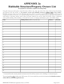 9
9 10
10APPENDIX 1
MAPS
Please provide maps and/or aerial photographs showing the following information. You may combine information on
maps as long as all required information is clearly identified and provided. It may be necessary to provide maps of
different scales in order to accurately depict the required information. This information is required per K.A.R. 28-18-4
and K.A.R. 28-18a-4.
Indicate at the top of all maps the Facility or Operator Name and County.
Orient all maps so “North” is at the top of the page and provide a “North Arrow.”
Use of portions of a standard 7.5 Minute USGS Topographical map is recommended. If a USGS Topographical map
is used, please identify the map sheet name used. USGS maps may be obtained by contacting:
Map Distribution
USGS Map Sales
Kansas Geological Survey
Kansas Geological Survey
Box 25286
1930 Constant Avenue
4150 Monroe Street
Federal Center, Bldg 810
University of Kansas
Wichita, Kansas 67209
Denver, Colorado 80225
Lawrence, Kansas 66047
(316) 943-2343
(888) 275-8747
(785) 864-3965
Suitable aerial photographs and maps may also be obtained from the local Natural Resources Conservation Services
(NRCS). A scaled drawing may also be used.
Please provide or identify the following information on a map:
□ Location and layout of the facility and facility property lines.
□ Location of all habitable structures within applicable separation distance as defined by K.S.A.65-171d(c)(5).
□ Location of areas at facility used for stockpiling process and animal wastes.
□ Locate and measure distance to draws, creeks, road ditches, etc.*
□ Show direction of surface drainage off lots and surrounding areas.
□ Specify size and type of vegetative filter strips and vegetative buffer if present or proposed.
□ Specify sedimentation basin dimensions and volume capacity if present or proposed.
□ Location of city or rural water district lines within 50 feet of the facility.
□ Location of all water, oil, gas, or salt solution mining wells on the facility property and within 600 feet of existing
or proposed wastewater retention structure.
□ Any streams, drainage channel, or body of water within one mile if the facility property lines.
□ Location of public water supply wells within one mile.
□ Location of any habitable structure, property lines, or parks within one mile of the facility property lines.
□ Locations of proposed/existing land application areas.
In addition for facilities with swine, indicate:
□ Location of all public water supply wells within 1,000 feet of the facility property lines.*
□ Location of all private water supply wells within 250 feet of the facility property lines.*
*Minimum separation distances apply to facilities with swine, per K.S.A. 65-1, 180 and K.S.A. 65-1, 194
KDHE BOW LWMS Permit Application form rev 4/7/2015
Page 7 of 10
ADVERTISEMENT
0 votes
Related Articles
Related forms


Related Categories
Parent category: Legal