Program Management Plan Page 4
ADVERTISEMENT
 1
1 2
2 3
3 4
4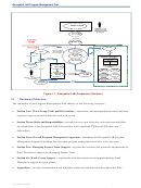 5
5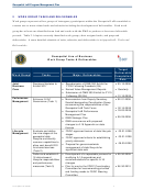 6
6 7
7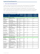 8
8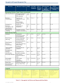 9
9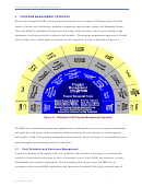 10
10 11
11 12
12 13
13 14
14 15
15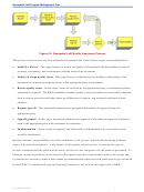 16
16 17
17 18
18 19
19 20
20 21
21 22
22 23
23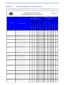 24
24 25
25 26
26 27
27 28
28 29
29 30
30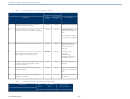 31
31 32
32 33
33 34
34 35
35 36
36 37
37 38
38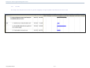 39
39 40
40 41
41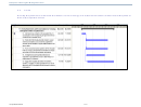 42
42 43
43 44
44 45
45 46
46 47
47 48
48 49
49 50
50 51
51 52
52 53
53 54
54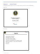 55
55 56
56 57
57 58
58 59
59 60
60 61
61Geospatial LoB Program Management Plan
1
INTRODUCTION
The Program Management Plan herein referred to as “the Plan,” lays out the Program Management
Office’s (PMO) approach for achieving the Fiscal Year (FY) 2008-2009 milestones of the Geospatial
Line of Business (Geospatial LoB) with contracting support from Grant Thornton. Herein, the term
“PMO” represents the combined parties of Grant Thornton and the Managing Partner Team. The Plan
builds upon the Performance Management Strategy (PM Strategy), which was completed in June 2007,
and the Performance Management Plan (PM Plan), which was completed in February 2008.
The Plan provides processes and tools to measure performance dimensions as introduced in the PM Plan
as well as practical approaches and tools for initiating, executing, and monitoring tasks, and producing the
deliverables presented in the PM Plan. Appendix A: Program Management Tool Summary Matrix
provides a comprehensive summary of key program management tools discussed throughout this Plan.
1.1
Background
In September 2007, the U.S. Geological Survey (USGS) of the Department of the Interior selected Grant
Thornton to provide program management office support to the Geospatial LoB. As part of this two-year
contract, Grant Thornton provides program support to the Geospatial LoB PMO in the setup and
implementation of various work groups producing multiple deliverables to enhance the efficiency and
effectiveness of the acquisition and distribution of geospatial data among Federal agencies.
The Federal Geographic Data Committee (FGDC) Coordination Group oversees the Geospatial LoB and
serves as the coordination board for operational-level interagency management for the effective and
efficient prioritization, execution, and administration of the Geospatial LoB and its tasks, milestones, and
deliverables.
Figure 1.1: Geospatial LoB Governance Structure provides a graphical depiction of the specific relationships
and reporting structures associated with implementing this initiative. The green dotted box outlines the
Geospatial LoB, whose participants come from participating agencies, with additional oversight from the
FGDC Chair, and Office of Management and Budget (OMB). While this graphic is notionally accurate, the
governance model may change over time as a result of the work products and deliverables produced by the
Performance Management Work Group in association with Task 1: Review/Update FGDC Guidance
Documents.
Last Updated 6/19/2008
3
ADVERTISEMENT
0 votes
Related Articles
Related forms


Related Categories
Parent category: Business